The Quest for Ancient Inscriptions: The results of a
challenging exploration of the Turkish-Iranian border in search of ancient
inscriptions possibly related to Noah’s ark
Abstract: The Turkish-Iranian border frontier near the Durupinar Noah’s Ark site in eastern Türkiye, characterized by its rugged beauty and ancient history, has been the subject of an initial archaeological surface survey. This study was launched to further examine and document purported ancient inscriptions, which were hypothesized to commemorate the landfall of Noah's Ark, based on preliminary findings by Ron Wyatt in the mid-1980s. Ron Wyatt's initial observations indicated the presence of distinct inscriptions and carvings on stone border markers, suggesting a potential archaeological link to the biblical narrative of Noah's Ark. To validate and expand upon these preliminary findings, our research team employed advanced drone technology for aerial documentation, ensuring a thorough and non-invasive examination of the stone markers scattered across this sensitive international border region.
Contrary to the initial hypothesis and the prevailing excitement surrounding Wyatt's discoveries, our detailed analysis revealed that these inscriptions are consistent with modern Farsi numbers, rather than ancient petroglyphs. This unexpected outcome underscores the critical importance of employing rigorous scientific methodologies with state-of-the-art technologies in archaeological investigations. Furthermore, it highlights the potential pitfalls of confirmation bias in the interpretation of archaeological data. This paper presents a methodical account of the research design, data collection, analytical procedures, and the consequent findings. The results serve as a demonstration to the dynamic and evolving nature of archaeological research, emphasizing the necessity for continuous scrutiny and reevaluation of historical claims in light of emerging evidence. Through this study, we aim to contribute to the broader discourse on the integration of technology in archaeological research and the critical examination of certain beliefs related to Noah’s Ark.
Keywords: Drone, Aerial Survey, Noah’s Ark, Durupinar,
Mount Ararat, Inscriptions
Introduction
![]()
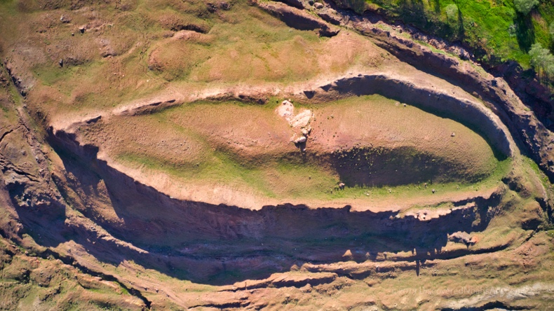 In this study, uphill from the Durupinar
Noah's Ark formation (Fig. 1) near Üzengili village
in the Doğubayazıt district we
investigate the possibility that stone markers along the international border
of Türkiye and Iran (Fig. 2) might have ancient
inscriptions associated with the story of Noah's Ark. The existence of
these inscriptions was first noted by Ron Wyatt in 1984.[1]
Markings on the stones were in three different scripts according to
Wyatt.
In this study, uphill from the Durupinar
Noah's Ark formation (Fig. 1) near Üzengili village
in the Doğubayazıt district we
investigate the possibility that stone markers along the international border
of Türkiye and Iran (Fig. 2) might have ancient
inscriptions associated with the story of Noah's Ark. The existence of
these inscriptions was first noted by Ron Wyatt in 1984.[1]
Markings on the stones were in three different scripts according to
Wyatt.
According to a book about Wyatt’s research into the Durupinar Noah’s Ark Formation in 1984, “As Ron [Wyatt] and Mr. Baser proceeded up the mountainside to the top of the ridge near the Iranian border, they encountered another amazing discovery. Near the top of the ridge, Ron found broken pieces of stone which contained an inscription. (Fig. 4 & 5) The pieces were being used in a more recent structure which looked to be a boundary marker. The broken pieces were quite large and most had the side with the inscription exposed which allowed him to see them so he could try to draw a reconstruction. These blocks contained numerous inscriptions in what looked like three different forms of writing, but he didn’t recognize any of them except the cuneiform… He believed there was only one explanation- that it was erected in historical times to mark the location of the original landfall of the ark.” [2] (Fig. 3 & 6)
Yet, Wyatt's claims have not been independently examined onsite until now, and archaeologists have not systematically studied the stones along the border. Due to the sensitive nature of the border area special permits were required to document the border markers especially with a foreigner on the research team. A drone was determined to be the best method due to the possibility of land mines in the area. Close-up drone photos of each side of these border markers revealed Farsi numbers and not ancient inscriptions as Wyatt had believed.

Figure 2 The locations and numbers of the Turkish-Iranian border markers above the Durupinar Noah's Ark Formation. Ron Wyatt theorized that Noah’s Ark landed at a higher elevation near the current border and later came down the mountainside to its current location. Image source: Andrew Jones, 2021.

Figure 3 Wyatt’s reconstruction drawing of a carving along the Turkish-Iranian border. The stone pieces of the carving he believed when assembled showed Noah's Ark with 8 figures inside the boat and 2 birds flying overhead. Image Source: Ron Wyatt.
|
Figure 4 Ron Wyatt in the mid-1980s standing next to border marker number 65 which shows a carving on the Iranian (south) side of the border marker with Mount Ararat (Ağrı Dağı) in the background to the north. Image source: Ron Wyatt, 1984. |
Figure 5 Border marker number 63 (Iranian side).Ron Wyatt believed the darkened carved figure on the left was a bird shape. The figure on the right is not explained. The book on Wyatt’s research, Doomsday Mountain, wonders why the figures were blackened. Image s |
|
|
|


Figure 6 Ron Wyatt thought that border marker number 65 showed the part of the reconstructed drawing that is circled in red. The partial oval shape he believed represented Noah’s Ark with a bird above it. Image source: Ron Wyatt, 1984.
Methods
Over the last 17 years, we have been exploring mostly on foot much of the area around and above the Durupinar Noah’s Ark Formation. (Fig. 7) Due to the border being off limits to foreigners and to even most locals we requested the help of a Turkish archaeologist in 2019.
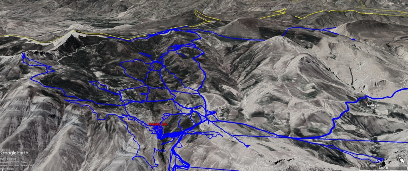
Figure 7 GPS tracks in blue along the Turkish-Iranian border (yellow line) showing all our exploration around and above the Durupinar Noah's Ark Formation from April 2014 to July 31, 2021. Image source: Google Earth.
Our research team consisted of three members: one Turkish archaeologist, one official from Türkiye’s Ministry of Culture and Tourism, and one American researcher who later was the drone operator. The Turkish archaeologist obtained the necessary permits and permissions from the Turkish and Iranian authorities to conduct the research, which took place over three visits on October 10, 2019, July 15, 2021, and July 27, 2021.
We used a DJI Mavic 2 Pro drone, equipped with a 4K camera and a GPS system, to capture high-resolution aerial images of the stone border markers from all sides along with a DSL and iPhone camera. We flew the drone at a low altitude of around 2-3 meters off the ground and maintained a safe distance from the border fences and markers without flying too far into Iran. Before we flew the drone we had already identified and located the stone markers based on Wyatt's descriptions, as well as our own observations from the 2019 and 2021 visits to the area and consultations with a local guide. We recorded the coordinates and photographed all sides of markers 64-67. We also noted the environmental and topographical features of the surrounding border area.
We collected and analyzed the drone data using various
software tools, such as Adobe Photoshop and Google Earth. We enhanced and
cropped the images to highlight any inscriptions and carvings on the stone markers
and compared them with Wyatt's photographs and drawings. We also compared the Farsi
numbers to the numbers used by the Turks. We consulted with other scholars in
the field to verify and cross-check our interpretations.
April 30, 2014 visit to the border
![]()

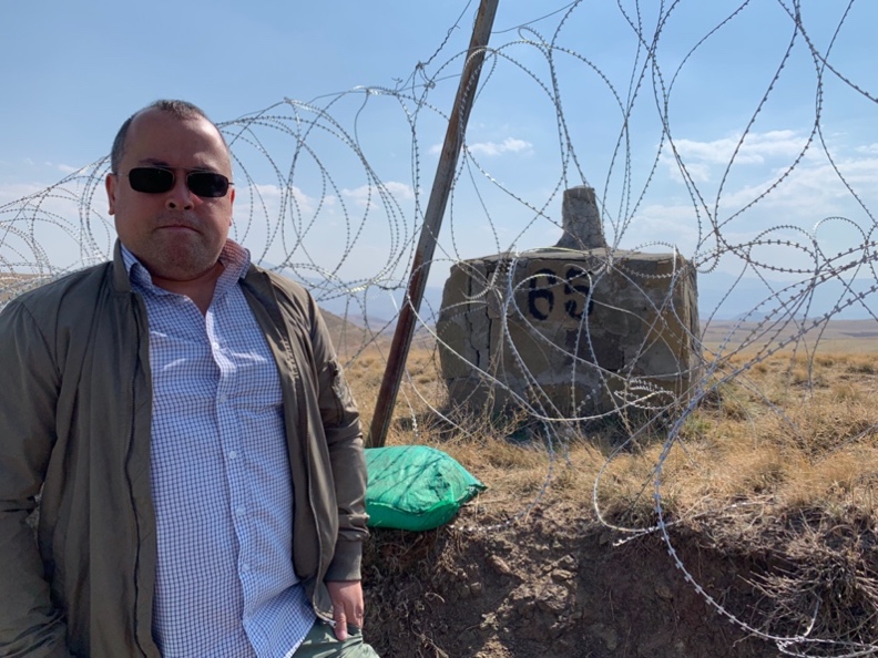
We made our first visit to the
Turkish-Iranian border on April 30, 2014, but the Turkish military base
commander at that time wouldn’t allow us to go out to the stone border markers
from the base. He was happy to take a photo with us (Fig. 8) and even said we
could explore Ron Wyatt's proposed Noah's ark original landing site valley
below his base but to beware of the Turkish sheepdogs. We decided it was best
to try to explore the landing site another time. We took notice of the
topography of the border area.
October 10, 2019 visit to the
border

 On October 10, 2019, we received official
permission to visit the border. Our team included a Turkish archaeologist and
an official from the Ministry of Culture and Tourism. We saw that there were several
border markers all along the border spaced approximately every 500 meters (Fig.
11) and that was when we found that the border markers were behind barbed wire
yet still standing and protected from tourists and locals. We were told though
that the ground on the other side of the barbed wire was mined so we couldn’t
yet get to all the sides of the stones in the markers to photograph them. We
were able to get close to border marker number 65 (Fig. 9 &10) which is the
stone marker that Ron Wyatt stood behind in his 1984 photograph. This marker Wyatt
claimed had a boat shape carved on it along with a bird.
On October 10, 2019, we received official
permission to visit the border. Our team included a Turkish archaeologist and
an official from the Ministry of Culture and Tourism. We saw that there were several
border markers all along the border spaced approximately every 500 meters (Fig.
11) and that was when we found that the border markers were behind barbed wire
yet still standing and protected from tourists and locals. We were told though
that the ground on the other side of the barbed wire was mined so we couldn’t
yet get to all the sides of the stones in the markers to photograph them. We
were able to get close to border marker number 65 (Fig. 9 &10) which is the
stone marker that Ron Wyatt stood behind in his 1984 photograph. This marker Wyatt
claimed had a boat shape carved on it along with a bird.

Figure 10 Border marker number 65 in black paint. Image source: Nilay iğrek, 2019.
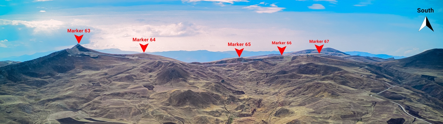
Figure 11 The locations and numbers of the Turkish-Iranian border markers above the Durupinar Noah's Ark Formation. The October 2019 clearly documented the border markers' numbering scheme for the Turkish side. Image source: Andrew Jones, 2021.
July 15, 2021 visit to the
border
In July 2021, permission was (Fig. 12) obtained to visit the
border markers in the Turkish military zone along the border with Iran with
permission from Ankara, the Turkish military and the Governor of Ağrı province and from the Iranians.
 First, on July 15th we visited the border
with a Turkish archaeologist and an official again from the Ministry of Culture
and Tourism to document as many of the stone structures with a DSLR camera. The
military border base commander was the same one we had met a month early at
Noah’s ark. He had come down to the visitor center to set up a photographic
display board about Noah’s ark for a high-ranking military officer visiting
from Ankara. We discussed the Durupinar Noah’s Ark Formation research
and we gave him a quick presentation about the geophysical surveys done at the
site and gave him two free books about Noah’s Ark. We got as close as we could
to border marker number 66 (Fig. 14 & 15) and went back to marker number 65
(Fig. 13) next to the Turkish military border tower.
First, on July 15th we visited the border
with a Turkish archaeologist and an official again from the Ministry of Culture
and Tourism to document as many of the stone structures with a DSLR camera. The
military border base commander was the same one we had met a month early at
Noah’s ark. He had come down to the visitor center to set up a photographic
display board about Noah’s ark for a high-ranking military officer visiting
from Ankara. We discussed the Durupinar Noah’s Ark Formation research
and we gave him a quick presentation about the geophysical surveys done at the
site and gave him two free books about Noah’s Ark. We got as close as we could
to border marker number 66 (Fig. 14 & 15) and went back to marker number 65
(Fig. 13) next to the Turkish military border tower.
We noticed that border marker number 65 had new cement covering a lot of the top and sides. It looked like it was just recently repaired by the military. The commander and his soldiers tried their best to help us and even put a wooden ladder over the barbed wire fence to get to the other side so we could photograph the Iranian side of marker number 65. We did ask the commander if the markers were on Turkish soil or not. He said they marked the exact border with Iran and that the south-facing side of the stone markers was in Iran. We photographed markers 65 and 66 as best we could as they were next to the barbed wire but the other markers were farther away from the Turkish barbed wire fence and impossible to photograph with the DSLR camera that we had with us. We knew that to better document all the sides of these markers that we needed a drone. We briefly discussed all this with the base commander and he was in agreement. We left to get the required permits to fly the drone in this military zone.

Figure 13 A DSLR photo of border marker number 65's eastern side from our second trip to border marker number 65. Image source: Nilay iğrek, 2021.

Figure 14 A DSLR photo of border marker number 66 north (Turkish) and west sides. Image source: Nilay iğrek, 2021.

Figure 15 A DSLR photo of border marker number 66 west and south (Iranian) sides. Notice the black Farsi numbers painted on the south (Iranian) side matching the black painted “66” painted on the north (Turkish) side. Image source: Nilay iğrek, 2021.
July 27, 2021 visit to the
border
On July 26th, we obtained permission for the use of a drone
on the subsequent day. We were given explicit instructions: our goal was to
capture photographs of the stone border markers only, while ensuring that we
did not include any images of Iranian territory or Turkish military structures
or personnel. The instructions were clear: we were required to maintain a low
flying profile and were only allowed to shoot still photographs. Video
recording was strictly forbidden. The initial drone flight was a little tense
with the base commander, military personnel, and officials observing the
operations, and a soldier was always positioned near the commander. The memory
card was changed after each flight to save as much data as possible in case the
drone was lost in Iranian territory.
Border marker number 65 (Fig. 16 & 18), which featured “boat” and “bird”
symbols that Wyatt had reported seeing in 1984, was the first to be documented.
This precaution was taken in case we encountered any issues with the subsequent
flights for the other three markers. Fortunately, the flights proceeded without
significant problems, except for a brief signal loss around marker number 64
(Fig. 17), which was not visible from our control point on the border road.
Consequently, we couldn't document the southern (Iranian) side of that marker.
There were no incidents involving the Iranians guarding the other side of the
border. As our group left the base commander came up and shook our hands and
called the drone operator “patron” (Turkish for “boss”). The Turkish
archaeologist informed us later that our request to operate a drone at the
border was highly unusual and that the approval came "from the very
top" in Ankara, allowing an American to fly a drone there—a
precedent-setting occurrence.
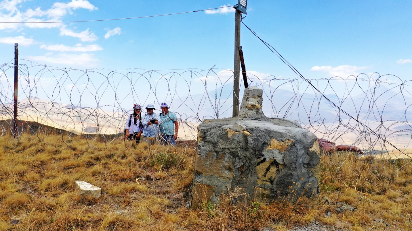
Figure 16 An aerial drone photo from Iran looking north towards the southern side of border marker number 65. This is the marker Ron Wyatt stood behind in his 1984 photo. Our research group is standing on the Turkish side of the border behind the Turkish barbed wire fence. Image source: Andrew Jones, 2021.
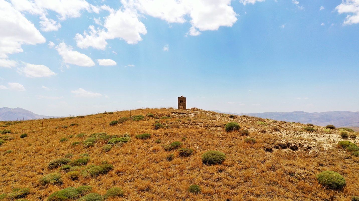
Figure 17 An aerial drone photo looking south toward border marker number 64 which is on a hill top further away from the barbed wire fence. We were only able to document 3 sides of this marker due to losing signal with the drone. Image source: Andrew Jones, 2021.
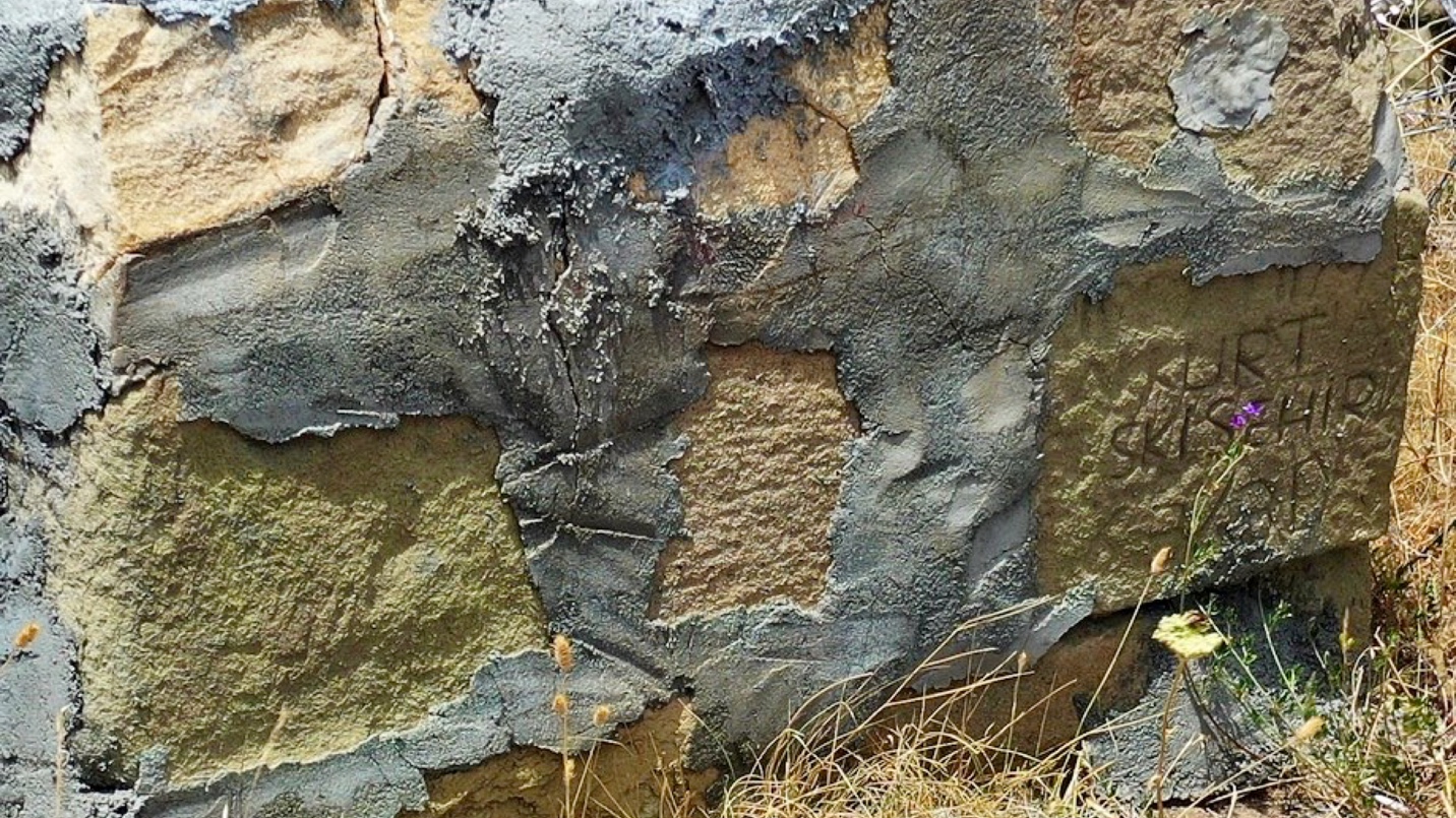
Figure 18 A drone close-up photo of the eastern side of border marker number 65. Notice all the cement used to hold the stones together. Image source: Andrew Jones, 2021.
Results
Our drone-assisted archaeological survey of the Turkish-Iranian border frontier near the Durupinar Noah’s Ark Formation resulted in the documentation and analysis of 4 stone border markers (Fig. 25, 26, 27 & 28), which bore various modern Turkish inscriptions and blackened carvings of Turkish and Farsi numbers. The markers were all about the same size and some looked to have been recently renovated and covered in cement. They were mostly rectangular in shape and were oriented north-south. They were located at an average distance of about 500 meters apart and were distributed along the border line (Fig. 19), with half of each stone border marker on the Turkish side and half on the Iranian side.
The inscriptions and carvings on the stone markers consisted of numbers, letters, and words. The numbers were all double digits and were written in Turkish or Farsi numerals with black paint or carved numbers painted black. The letters and words were mostly abbreviations or names and dates and were written in Turkish script representing the names and enlistment year of Turkish soldiers stationed along the border. Some of the inscriptions and carvings were clear and legible, while others were partially covered in cement or eroded.
Contrary to our initial hypothesis and the prevailing excitement surrounding Wyatt's discoveries, our detailed analysis revealed that these carvings are consistent with modern Farsi numbers (Fig. 20, 21, 23, & 24), rather than ancient petroglyphs. The Farsi numbers on the south (Iranian) side corresponded to the numbers on the north (Turkish) side of each stone border marker. Specifically the boat symbol that Wyatt had seen turned out to be part of the Farsi number 5 which looks like an upside down heart. We found no evidence of any ancient language or script, such as Urartu or Armenian, on the stone border markers. Nor did we find any evidence of any ancient iconography or symbolism, such as animals, plants, or religious motifs, on the stone markers. Instead, we found that the inscriptions and carvings are most likely related to the modern border military patrols, the border demarcation and administration, such as surveying, mapping, and monitoring. We concluded that the inscriptions and carvings are the products of the 20th or 21st century, not the ancient past.
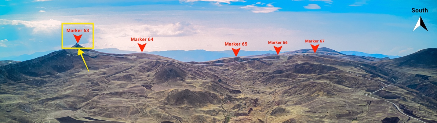
Figure 19 Location of border marker number 63 which was not documented with our drone. We didn’t realize Ron Wyatt’s 1988 photo in Fig. 24 was border marker 63. We assumed it was border marker 64. So our permit did not cover going to marker 63 on the top of that ridge. Image source: Andrew Jones, 2021.

Figure 20 Border marker 63's south (Iranian) side. Blackened carving is the Farsi number "63.” Our drone did not document this border marker. Image source: Ron Wyatt, 1988.
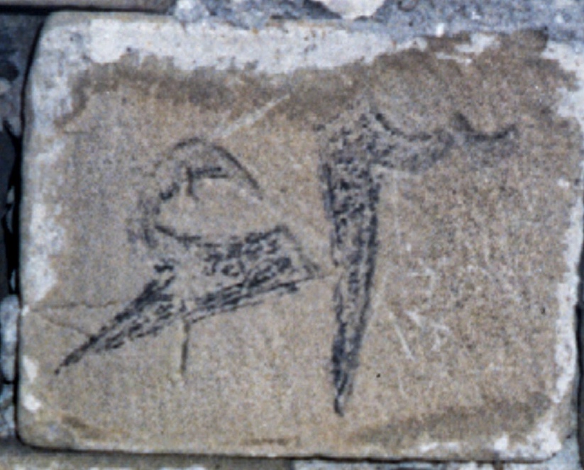
Figure 21 A closer examination of Wyatt's photo of border marker number 63 with the carving shows that it’s Farsi number 63. Wyatt had mistakenly interpreted the “6” as a bird petroglyph. Image source: Ron Wyatt, 1988.

Figure 22 Location of border marker number 65. Image source: Andrew Jones, 2021.

Figure 23 Close-up of a stone in border marker 65's south
(Iranian) side. The carving turns out to be the Farsi number 65. Our drone did
not see this stone. Restoration work on the border marker after Ron Wyatt’s
1984 and 1988 visits covered a lot of the stones in the border marker with
cement and older stones were replaced. Image source: Ron Wyatt, 1984.

Figure 24 A closer
examination of Wyatt's photo of border marker number 65 with the carving shows
the Farsi number 5, which looks like a heart upside down and not a boat. The
bottom part of the “boat” carving can be seen to curve upward exactly how a
Farsi 5 is written. The orientation of the stone sitting in the border marker
is correct in how Farsi "65" would be carved. Image source:
Ron Wyatt, 1984.

Figure 25 Drone photos of 3 out of 4 sides of border marker number 64. The drone lost contact with the controller briefly while on the southern (Iranian) side of marker 64 and it did not take any photos of this far side. Image source: Andrew Jones, 2021.

Figure 26 Drone photos of all sides of border marker number 65. This is the marker Wyatt believed had a blackened carving of the important boat shape with a bird flying above it. Image source: Andrew Jones, 2021.

Figure 27 Drone photos of all sides of border marker number 66. Image source: Andrew Jones, 2021.
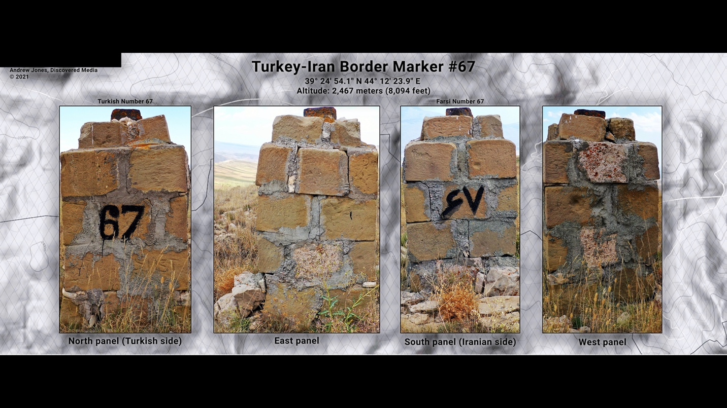
Figure 28 Drone photos of all sides of border marker number 67. Image source: Andrew Jones, 2021.
Conclusion
This study provides a systematic description of our
archaeological surface survey of the Turkish-Iranian border frontier near the
Durupinar Noah's Ark Formation, using a drone. It also includes the resulting
discoveries. We conducted a thorough examination and recorded the alleged
ancient inscriptions and carvings found on the stone boundary markers. These
markers were believed to have been created to commemorate the arrival of Noah's
Ark, based on initial discoveries made by Ron Wyatt in the mid-1980s. We utilized
drone technology to conduct airborne documentation, guaranteeing a
comprehensive and non-intrusive inspection of the stone markings. In addition,
we utilized analytical approaches to authenticate and decipher the inscriptions
and carvings.
Our investigation revealed that the inscriptions and carvings on the border
markers are in line with contemporary Farsi numbers, rather than being ancient
petroglyphs associated with Noah's day.
Our paper aims to enhance the progress and comprehension of the archaeology and history of the Turkish-Iranian border boundary, as well as the tradition surrounding Noah's Ark. In addition, we anticipate that our work will stimulate the adoption of technology in future investigations and study of this captivating and intricate location, as well as its abundant and varied cultural legacy.